


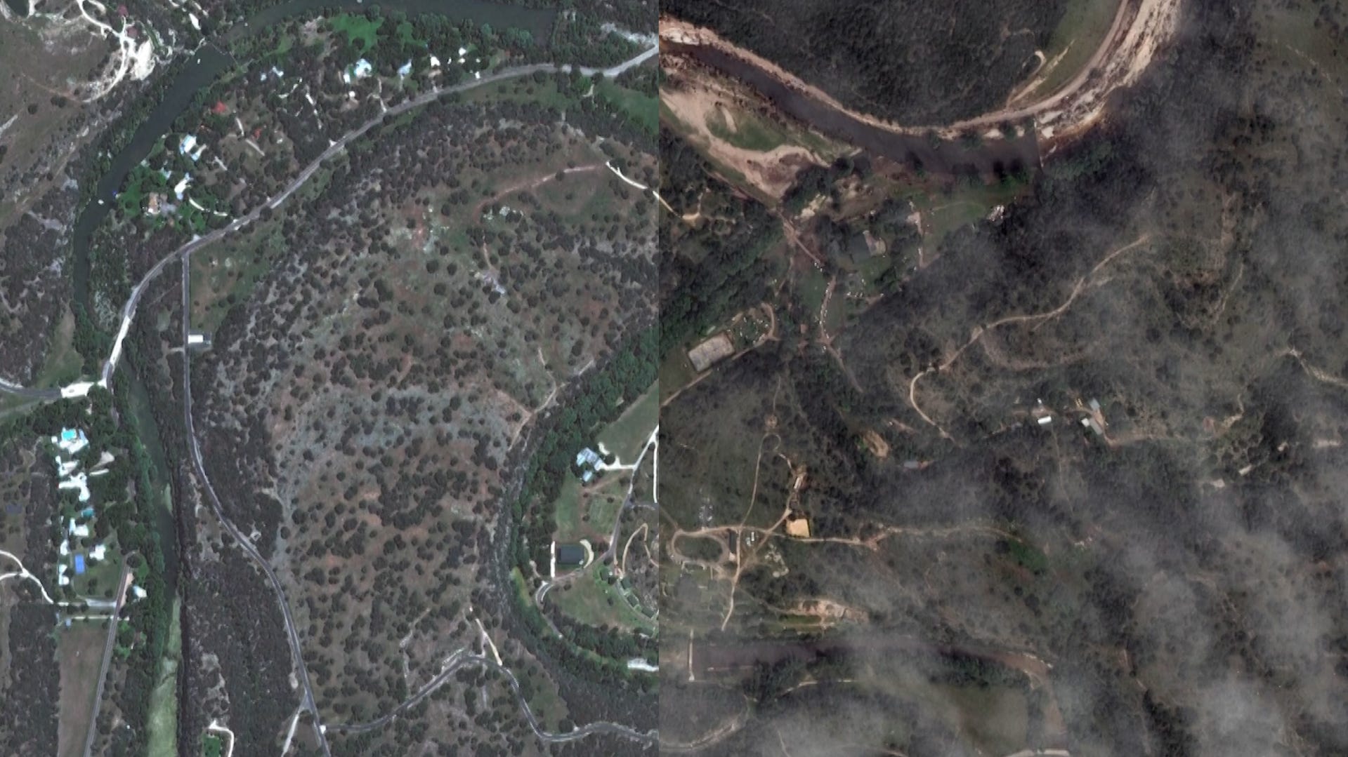
See scope of Texas flooding devastation through satellite images
Satellite images show the devastation left behind by flash floods in Kerrville, Texas.
- At least 100 people were killed and dozens remain missing after flash floods caused by the Guadalupe River surge in Texas following torrential rain on July 4th.
- Several factors, including heavy rainfall, the region’s topography, and thin soil, contributed to the devastating floods in Texas Hill Country, an area known as “Flash Flood Alley.”
- While Florida experiences heavy rainfall and hurricane-related flooding, flash floods similar to those in Texas are unlikely due to the St. Johns River’s flat terrain and sandy soil.
After flash floods in Texas killed at least 119 people and left dozens unaccounted for when the Guadalupe River surged following torrential rain on Fourth of July, it’s worth wondering if the same catastrophic flooding could occur along the St. Johns River in Florida.
Here’s a look at what happened in Texas and what factors, if any, might impact a similar scenario along the 310 miles of the St. Johns River in Florida.
What happened during the Fourth of July Texas floods?
Texas Hill Country is no stranger to extreme flooding.
The Guadalupe has flooded more than a dozen times since 1978, according to the U.S. Geological Survey, but the Independence Day flood is among the worst in its history.
Several factors came together at once — in one of the worst possible locations — to create the “horrifying” scenario that dropped up to 16 inches of rainfall in the larger region over July 3-5, Alan Gerard, a recently retired storm specialist with the National Oceanic and Atmospheric Administration told USA Today.
Hill Country, the region in Central and South Central Texas, also is known as “Flash Flood Alley,” for its propensity for fast and furious flooding when extreme rain falls.
As bountiful moist air from the Gulf of America, renamed from the Gulf of Mexico, moves over the steep hills, it can dump heavy rains.
What is ‘Flash Flood Alley?’
The Balcones Escarpment, a geological feature which roughly parallels Interstate 35 in Texas, marks the edge of Flash Flood Alley, according to AccuWeather.
The inactive fault zone formed a rise in the topography in the area, which enhances storm systems that pass over it, causing them to dump more rain there than they might elsewhere.
The likelihood of flooding is exacerbated by the transition from elevated hill country to coastal plains, according to experts with the Lower Colorado River Authority. Additionally, the landscape is characterized by very thin soil that doesn’t absorb much rain.
Those factors combined with warm, moist air from the Gulf fuel storms, enabling them to dump lots of rain in a short amount of time on the dusty soil.
Could flash floods similar to Texas happen on the St. Johns River?
Although Florida has no shortage of the moist tropical air that contributed to the rainfall that caused the catastrophic Texas floods, there’s virtually no chance of flash floods along the St. Johns River, said Jessie Schaper, meteorologist and hydrology program manager at the National Weather Service in Melbourne.
“Absolutely not,” Schaper said of the potential likelihood of flash floods in Florida.
“We do not have the terrain here that they do in Texas Hill Country, so that type of thing we’d never see on the St. Johns,” she said. “It is a very slow-moving river. It drains a large area, but it’s essentially flat.”
The St. Johns River has a very low elevation drop, less than 30 feet over its 310-mile length. That translates to an average drop of about 1-inch per mile, making it one of “laziest” rivers in the world, according to the St. Johns River Water Management District.
“Think about water in a tray. That’s really all that there is. It flows very slowly, and it takes a long time to drain the water out to the Atlantic. We don’t see rainfall rushing down the side of a hill or mountain into the St. Johns River.”
Another key difference between Texas and Florida is the soil, Schaper said.
“We could see a heavy rainfall event, but the topography of Florida is totally different than that area of Texas,” she said. “We have very sandy soil and it absorbs water very quickly. Three inches of rain here looks very different than 3 inches out west, where there’s really rocky soil.”
How does Florida hurricane flooding compare with the Texas flood?
At the same time, flooding has been a part of recent tropical storms and hurricanes from Ian and Nicole in 2022 to Milton this past fall, as anyone in Daytona Beach’s historic Midtown neighborhood or along the St. Johns River near DeLand can attest.
The highest historic crest of the St. Johns River near DeLand was 6.33 feet recorded on Oct. 11, 2022, during Tropical Storm Ian, according to the National Weather Service.
Such inundations are different from the flash floods that ravaged Texas, Schaper said.
“We get concerned about it during hurricane season, of course, but it’s not about a flash flood,” she said. “It’s more of a long-term flood that might last for weeks or months at a time, not so much the drastic rise of water that it was in Texas.
“During Milton we saw 15 inches of rain, and during Ian some locations had 20 inches,” she said, noting that those totals were in the range of the 16 inches that fell on the larger Texas Hill Country region over the holiday weekend.
Although flash floods aren’t a specific concern, Florida has become prone to hurricane-generated storm surges that have increasingly become dangerous flooding events with inundation. Whether from coastal storm surges or inland rising water, such events can pose just as much or more of a risk than hurricane winds.
Reporter Dinah Pulver of USA Today contributed to this report.


