
The United States has entered the peak of summer and a new heat dome — sealing in all that hot, humid air — is about to make millions of people feel every bit of it.
Some cities could notch their highest temperatures of the year as heat builds from the South to the Midwest this week while humidity drives the heat index, or how hot it will actually feel, well into the triple digits.
Sizzling conditions were starting to set up from the Gulf Coast to the Plains on Tuesday, with nearly 60 million people under heat alerts from Florida to South Dakota.
Heat remains the deadliest form of extreme weather in the US. Globally, heat waves are becoming more frequent, more severe and lasting longer as the world warms due to fossil fuel-driven climate change.
The heat will ramp up in intensity and expand to the Midwest on Wednesday. Brutal temperatures will stretch from the South through the Midwest on Thursday and also start to push into the East.
Wednesday and Thursday could be the new hottest days of the year in cities like Chicago, St. Louis and Memphis, Tennessee: Chicago and St. Louis are expected to soar into the upper 90s both days while Memphis could flirt with the triple digit mark starting as early as Tuesday.
Unlike the intense heat wave earlier this summer, this bout of stifling heat isn’t likely to topple hundreds of records. But records don’t need to fall for heat to be incredibly dangerous: A Level 3 of 4 heat risk stretches from the Gulf Coast to Minnesota on Tuesday and as far north as Michigan’s Upper Peninsula on Wednesday.
This level of heat risk means anyone without access to effective cooling or proper hydration is impacted, not just vulnerable populations, according to the National Oceanic and Atmospheric Administration. And for those without air conditioning, staying indoors can become deadly during the hottest parts of the day, the agency warns.
The heat index — also known as the apparent temperature — will soar to dangerous levels for tens of millions this week.
It will reach the triple digits from the South up to parts of Minnesota and South Dakota on Tuesday. By Wednesday, some parts of the Mississippi Valley, including Memphis, could have a heat index of between 110 and 115 degrees.
Humid conditions will also prevent temperatures from cooling significantly overnight. It could still be close to 80 degrees in St. Louis by sunrise Thursday — nearly 10 degrees higher than a typical low for July.
When overnight temperatures don’t cool down enough to offer relief for overheated bodies, people are at greater risk for heat-related illnesses. Nighttime temperatures are taking the hardest hit from climate change, warming faster than daytime highs.
The heat will ramp up considerably Thursday in parts of the Ohio Valley and start to reach into the Northeast. Detroit, Cleveland and Cincinnati could come within a degree of or match their hottest day of the year so far, with expected highs in the 90s. These highs are about 10 degrees hotter than what’s typical even in this hottest month of the year.
The most intense heat for the East Coast will arrive by Friday, with high temperatures in the middle to upper 90s and a heat index of 100 degrees or more possible for Washington, DC, Philadelphia, New York City and Boston. High temperatures in this range are also up to 10 degrees hotter than typical for these cities.
The heat dome will ease by Saturday for many, replaced by more typical, though still very toasty, late July temperatures.
For many in the contiguous US, it’s been sweltering since meteorological summer — June through August — began. The bulk of the heat has been focused on the East, where dozens of locations are so far on track for their hottest summer to date.
Many more locales are currently experiencing at least one of their 10-hottest summers to date. The Northeast, Mid-Atlantic, Ohio Valley and Midwest have all been literal hotspots.
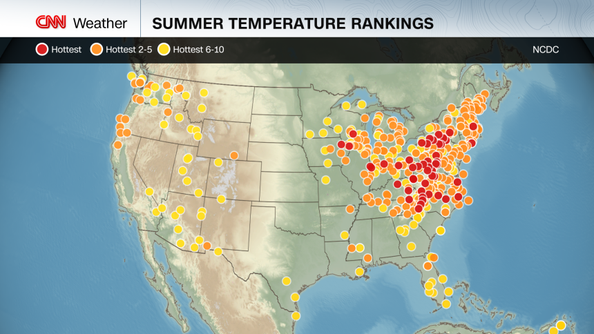
Rather than searing daytime temperatures driving the above-average heat in these locations, it’s been many, many instances of too-warm overnight lows making the biggest impact, according to a CNN analysis of data from NOAA’s National Climatic Data Center.
The Plains have so far dodged this really hot summer. Much of the West has too, with a few exceptions: Seattle is having its fifth-warmest summer to date while Portland is hovering around seventh-highest.
Tiny pockets of cooler-than-normal summers are few and far between in the US, but the San Francisco Bay Area in California is one of them. Parts of the Bay Area — including Oakland and Fremont — are experiencing one of their coolest summers to date.
August will likely be another hot month for much of the country, according to the Climate Prediction Center’s latest forecast. Cities that are already baking could continue their hot streak while other places that have escaped the worst could still warm up a bit in the latter part of summer.